With thanks to Rebecca Nesvet, Institute for Research in the Humanities, University of Wisconsin for this blog contribution.
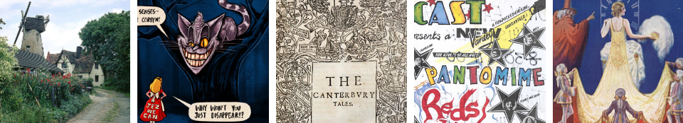
Sweeney Todd, the Demon Barber of Fleet Street, glares menacingly and a bit provocatively out of a 1927 picture postcard, a component of the Melville Collection at the University of Kent at Canterbury’s Special Collections. As played by actor Andrew Melville II (1882-1938), Todd is an eighteenth-century artisan, his hair bound back into a ponytail, his sleeves voluminous. He frowns at the viewer, refusing to share his terrible business secrets. Sweeney Todd, demonic personification of the man-eating metropolis of the industrial revolution, would seem to have little to do with the Kentish countryside, but at the Templeman Library’s Special Collections, they are connected.
Photograph of a black and white print showing Andrew Melville as Sweeney Todd in SWEENEY TODD (MEL/PHO/A II : 600643)
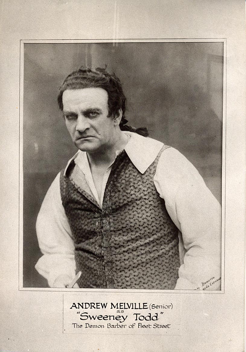
Among the Templeman’s treasures of local history are two copies of Christopher Greenwood’s 1838 Epitome of County History… of Kent. In 1838, Greenwood was Britain’s top practitioner of antiquarian mapmaking.[1] Many of his maps described counties or larger regions in England and Wales and he also published an Atlas of the Counties of England and Wales, ‘engraved with forty-six … vignette views’ (1828). According to Greenwood’s biographer J.B. Harley, Greenwood’s maps were ‘essentially transitional in character between the traditional features of eighteenth-century map-making and the new era of scientific cartography inaugurated by the Ordnance Survey’.[2] Greenwood was also exceptionally well-connected. He counted among his patrons many aristocrats and the late King George IV.[3]
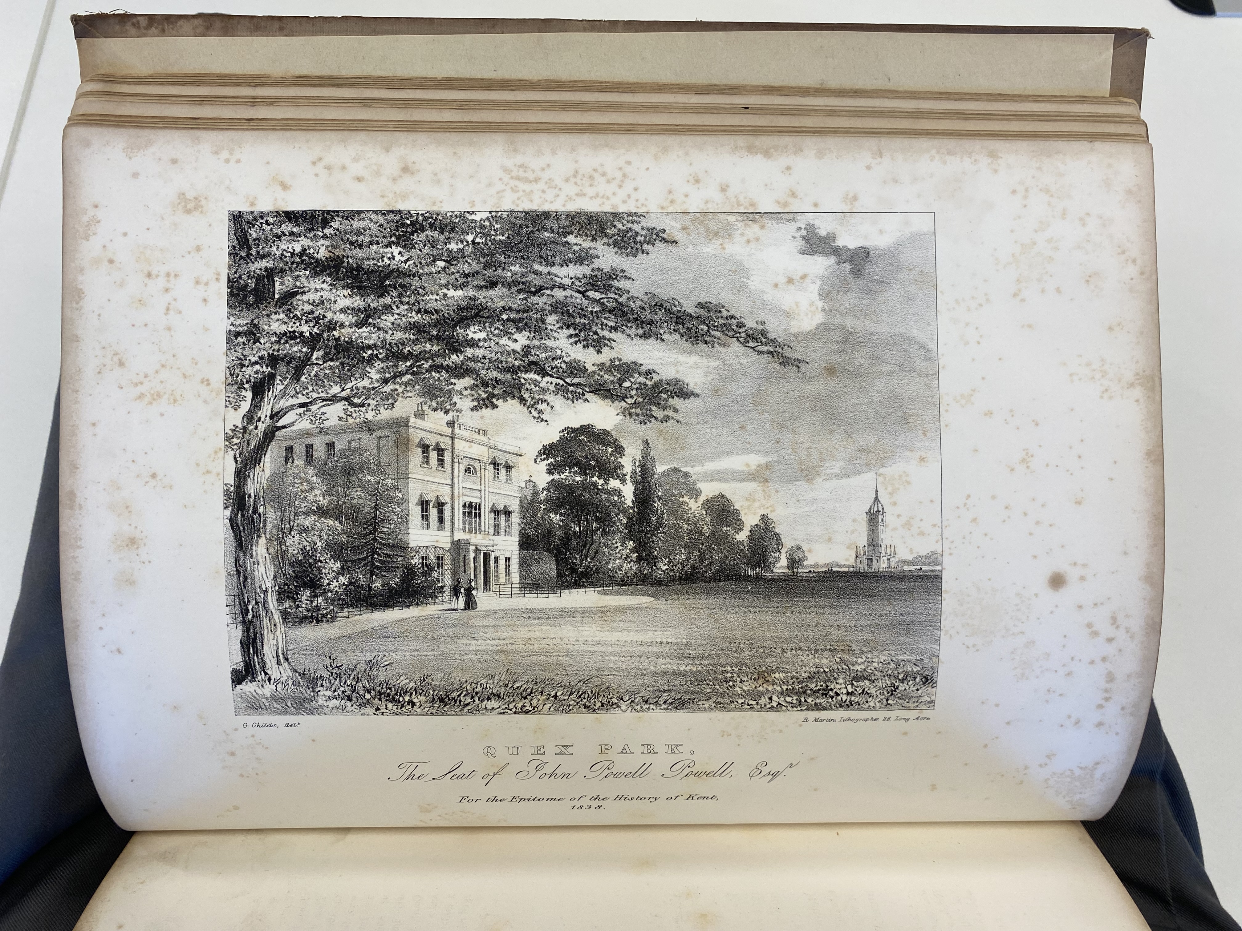
An epitome of county history wherein the most remarkable objects, persons and events are briefly treated of the seats, redidencies, etc. of the nobility, clergy and gentry … : each county illustrated by a map. V. 1, County of Kent (Q DA 1001, Baldwin Collection)
Evidently, Greenwood planned a multi-volume series of geographies of several counties. In the end, he only completed the volume concerning Kent. This Epitome consists of an elaborate, up-to-date map of Kent (see above) and a description of its natural and human geography. A collection of plates illustrate Canterbury Cathedral and many of the county’s stately homes. In some surviving copies, the plates are bound into the volume, adjacent to Greenwood’s descriptions of the landmarks they illustrate.
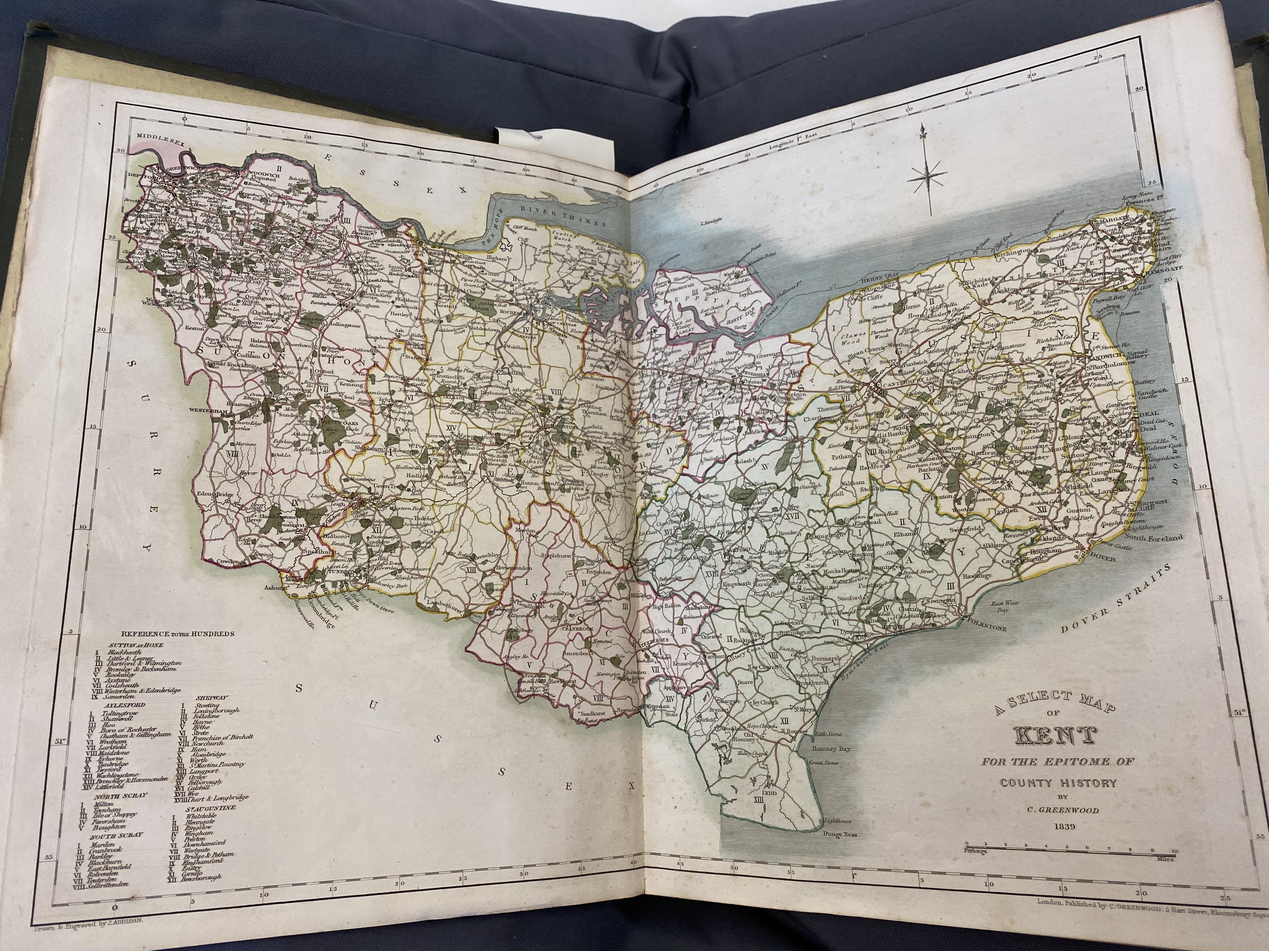
Two very different copies of Greenwood’s Epitome can be found at the Templeman Library’s Special Collections. One was bound by local antiquary, a Mr Armitage, into four gilt-edged volumes. Besides Greenwood’s pages, the four volumes also contain other material illustrative of Kent’s topography and history. Interpolated throughout, this material reveals what important Kentish landmarks looked like throughout the eighteenth and nineteenth centuries and in media ranging from woodcuts and lithographs to early photography. Armitage’s bricolage of Greenwood’s Epitome and other representations of Kent is a meticulous, unique, labour of love.
An epitome of county history: Vol 1, County of Kent, presented by Mrs P.M. Armitage (Q DA 1001)
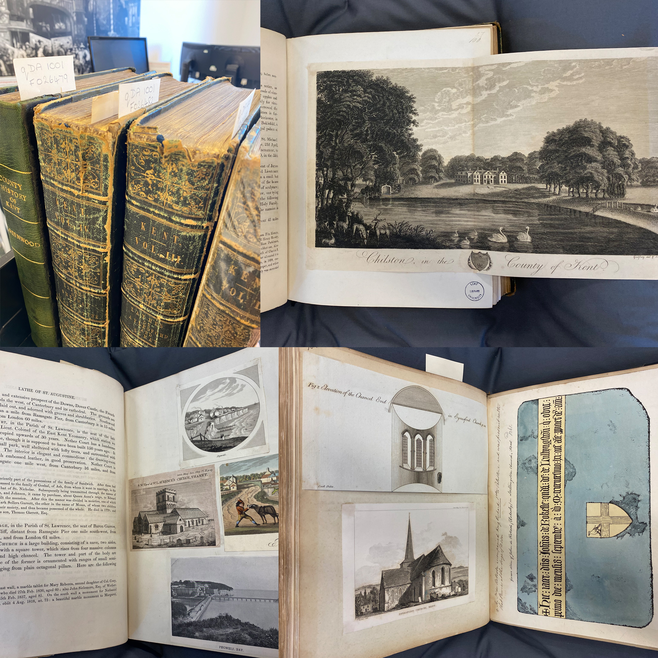
Recently, Special Collections acquired another copy of Greenwood’s volume. This copy consists primarily of plates. Bound in boards, it isn’t as elaborate or personal as Armitage’s project, but it showcases the lithographs of Kentish houses that Greenwood wanted his elite subscribers to appreciate. In these lithographs, published eight years after the ‘Swing Riots’ broke out in the Elham Valley and then convulsed rural England, the Kentish countryside appears tranquil. Agricultural workers go about their business in the fields surrounding their landlords’ estates. Paging through this prints-only volume feels like touring a pastoral panorama of Kent.
An epitome of county history wherein the most remarkable objects, persons and events are briefly treated of the seats, redidencies, etc. of the nobility, clergy and gentry … : each county illustrated by a map. V. 1, County of Kent (Q DA 1001)
The connection to Sweeney Todd is a detail of the plates. One of the Illustrators, “G. Rymer,” is apparently Gaven Rymer (c.1812-42), artist and engraver.[4] Rymer is the only artist-engraver of that era with his initials, and the publications of “G. Rymer” appear to end with his premature death at the age of approximately thirty.
Rymer was from Clerkenwell: one of London’s poorest parishes, but also a vibrant artisanal community, the home of many engravers, with a rich radical history. It is not unusual that Rymer worked for Greenwood, who kept an office in Bloomsbury. However, while one of Greenwood’s other artists boasted in the Epitome of having drawn his illustrations ‘on stone, from nature’, Rymer almost certainly drew his in London, exemplifying resourceful Cockney transcendence of urban surroundings through art.
In one of Rymer’s three illustrations, ‘Chilham Castle, the Seat of Ja[me]s] B. Wildman, Esq.’ (fig. 3), he might have made a small political intervention in the commissioned composition. Most of the second volume’s prints depict the houses in relatively close perspective, showing off their architectural detail, while a few keep them in the background, showing the vastness of the attached lands. In ‘Chilham Castle’, however, the stately house is centred but small and far away. In the foreground, farmers load a wagon with hay. They face forward and their mise-en-scene fills the lower righthand corner, causing the reader’s eye to travel from the manor house to the workers and finally the overflowing cart and dray animal. Without the title ‘Chilham Castle’, this image would seem more a portrait of the harvesters than a celebration of Wildman’s manor house.
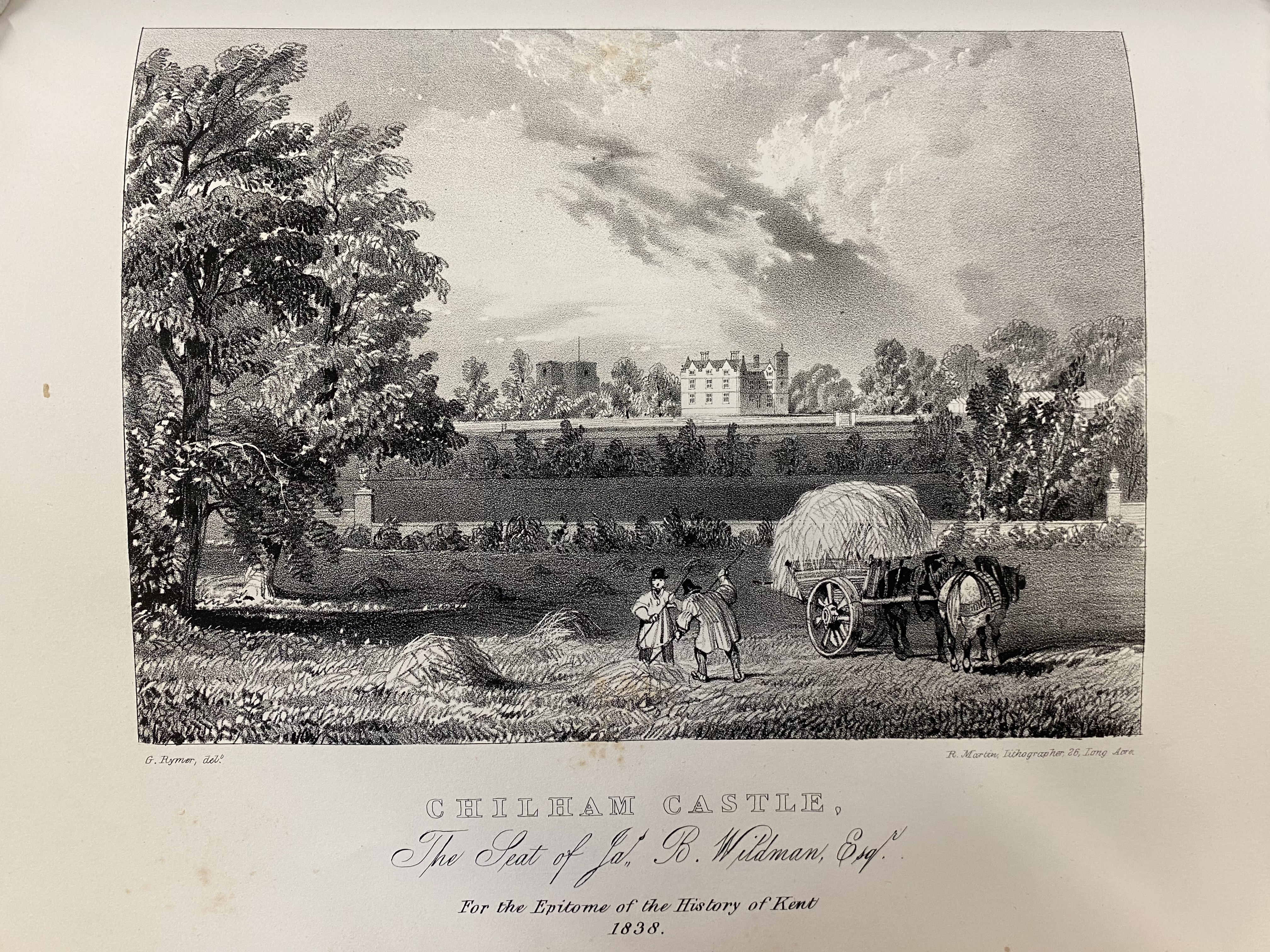
Engraving by Gaven Rymer of Chilham Castle, An epitome of county history wherein the most remarkable objects, persons and events are briefly treated of the seats, redidencies, etc. of the nobility, clergy and gentry … : each county illustrated by a map. V. 1, County of Kent (Q DA 1001)
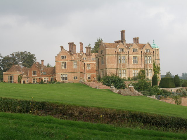
Chilham Castle, 21st Century. Wikimedia Commons (379208.jpg)
As for the Sweeney Todd connection, Rymer’s brother James Malcolm Rymer (1814-84) was a prolific author of “penny dreadfuls”: cheap, imaginative illustrated fiction serials, some of which are represented in the Templeman’s collections. James Malcolm Rymer created Sweeney Todd in his 1846-7 fiction serial The String of Pearls, a Romance. While James Malcolm Rymer invented a fantasy geography in which monsters waylay unsuspecting visitors to central London, his artist brother brought Kentish idylls to visual life. Now, their creations share a home at the Templeman Library.
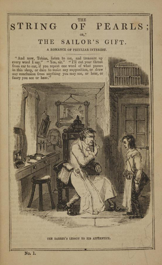
The string of pearls, or, The barber of Fleet street : a domestic romance. Source: Internet Archive.
[1] J.B. Harley, Christopher Greenwood, County Map-maker, and his Worcestershire Map of 1822 (London: Ebenezer Baylis & Son, 1962), viii. Museum.
[2] Harley, Christopher Greenwood, 25.
[3] Harley, Christopher Greenwood, 27.
[4] ‘Gaven Rymer’, 1841 UK Census. Class: HO107; Piece: 660; Book: 8; Civil Parish: St James Clerkenwell; County: Middlesex; Enumeration District: 15; Folio: 34; Page: 23; Line: 8; GSU roll: 438777. Ancestry.com mistranscribes Gaven’s name as ‘Gravers’, but the facsimile makes the spelling clear.
Written by Rebecca Nesvet, Institute for Research in the Humanities, University of Wisconsin, nesvetr@uwgb.edu