This month’s post has been written by Brittany Stone, M.A. student in Roman History and Archaeology at the University of Kent.
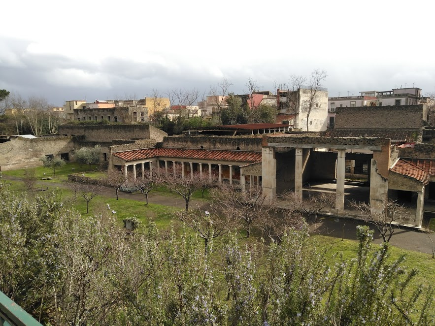
Figure 1: View from main entrance, modern street level
One of the key moments of Roman history is the tragic fate of Pompeii in 79 CE. Located around modern Naples, about 220 kilometres south of Rome, the ancient Roman town of Pompeii had the misfortune of suffering a volcanic eruption from nearby Mount Vesuvius. The eruption and its subsequent ashfall covered the city and preserved its victims, turning the area into a time capsule of the past. Today, Pompeii is a major attraction, not only for historians and archaeologists, but for tourists from all over the world who wish to explore an authentic Roman town. However, the outcomes of Vesuvius’ eruption caused more destruction than simply the city of Pompeii. Indeed, several other towns were trapped by the eruption and buried in ash, including several villas. These less frequented sites are Herculaneum, Stabia, Boscoreale, and Oplontis. Today’s article focuses on Oplontis and our knowledge of this site that relies on not only archaeology but also other fields such as volcanology, paleoecology and osteology.
Oplontis was a seaside resort located five kilometres to the west of Pompeii. Today the site refers to a group of villas in the modern town of Torre Annunziata. The only historical reference to the name Oplontis is on the Peutinger Map (Latin name Tabula Peutingeriana), a 13th-century copy of an ancient map of the Roman Empire. This incredibly large map, nearly seven metres long by less than half a metre wide, illustrates the road network of the Roman Empire. It shows Oplontis with Vesuvius looming ominously behind it, on the road between Pompeii and Herculaneum. Without this map, all contemporary reference regarding Oplontis would have been lost. Like Pompeii, knowledge about Oplontis was forgotten and only discovered by chance.
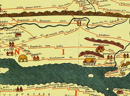
Figure 2: Peutinger Map, Neapolis – Herculanum – Oplontis – Pompeii route
Oplontis’ first villa (Villa A) was rediscovered in the 1590s during the construction of the Sarno Canal. It was referred to as Villa Poppaea because it was believed to be have been owned by the family of Poppaea Sabina, the second wife of Emperor Nero. Unfortunately, no other excavation were carried during the following four centuries until 1964 when the Italian Ministry of Culture decided to have the site excavated again. Ten years later in 1974, the construction of a local school unearthed the remains of a second villa (Villa B), located 300 meters down the street from Villa A. The subsequent excavations determined that Villa A was a richer residence than Villa B, which displayed more of an industrial nature and seems most likely to have been a wine distribution centre. At Villa B, the discovery of a seal bearing the name of Lucius Tertius Crassus has led archaeologists to believe he was the owner of the villa. Villa A, however, remains the most well-known due to the extravagant and impressive nature of its gardens and the exquisite collection of surviving frescoes.
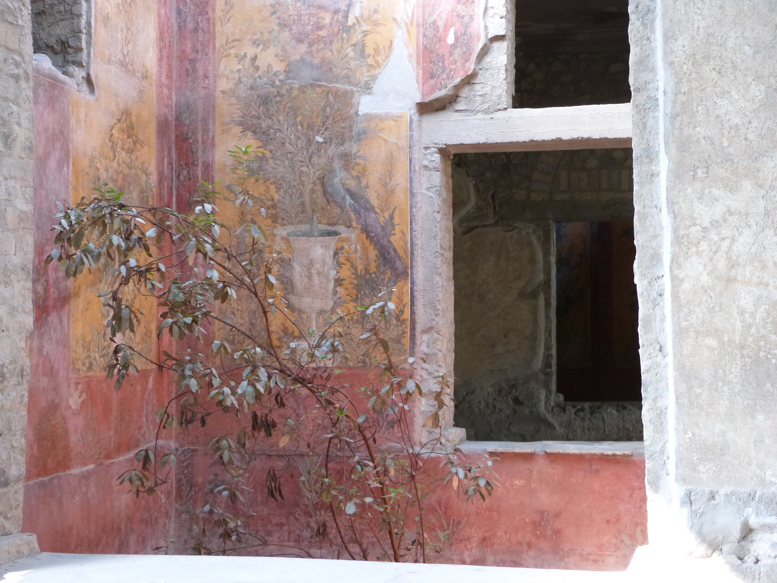
Figure 3: Garden alcove with matching wall painting
While Pompeii owes its popularity to its ability to illustrate Roman everyday life, Oplontis is known for its wealthy houses. As Villa A belonged to the family of the Emperor’s wife, the artworks, gardens and house itself display what unlimited money could buy in the ancient world. The dating of houses in the Pompeiian region can be determined from the style of its artwork (four distinct styles are preserved). Villa A can be dated to the mid-first century BCE based on five rooms that were done in the second style, also known as architectural style which began around 90 BCE. These rooms, including the front room (atrium) and the dining room (triclinium), are the most complex examples of architectural perspective to survive from antiquity. Since it belonged to a prestigious family, the house was renovated several times following the latest fashion. For instance, the walls of its bath complex (caldarium) originally displayed artwork painted in style three, an ornamental style popular from 20 BCE onwards. Thanks to archaeological investigations into the site’s context and region’s contemporary environment, we also know that the villa’s gardens had walls covered in painted greenery. This along with the ancient seeds found around the site have enabled archaeologists to recreate an ancient garden.
The layout of Villa Poppaea is extensive, designed as a space for luxury and decadence. Due to the modern street layout, the original entrance to the villa is now blocked off, forcing modern access to the site from the north at the back of the villa. Meanwhile, the west wing of the villa is trapped beneath the road complicating the excavation of that half of the site. Although Villa A was comfortable and grandiose, excavations did not find any surviving furniture or bodies on site, prompting the conclusion that no one was living there at the time of the final eruption. One of the reasons for such abandonment is that general renovations from damages caused by earthquakes in the 60s CE were in progress. Construction work on the site would also explain that furniture had been previously removed.
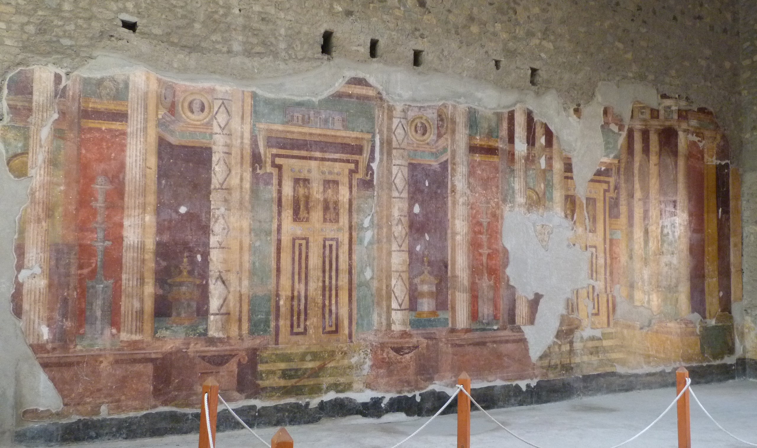
Figure 4: Atrium with Second Style design
In contrast, Villa B served an industrial purpose and its owner might have remained on the site despite the volcano’s multiple warning signs. The family was probably reluctant to leave their possessions. A bronze bathtub, various forms of gold jewelry and a decent amount of Roman currency (10,000 sesterces) were excavated. In addition to these, archaeologists have discovered 54 human remains so far. In the 1980s, 33 bodies were removed from the site and studied, while the rest are to be excavated this summer (2018). So far, results have determined that the individuals were healthy (Oplontis was free of diseases such as malaria) despite the analyses of the teeth that revealed prolonged illnesses and hunger. The investigations are still going on and researchers are trying to learn about the diet and health of the people living in Oplontis during the years before the eruption, from the first earthquake in 62 CE to August 24th, 79 CE. This will allow scientists to create a small-scale reconstruction of the area’s environment to see how the volcano affected the soil, farming and living habits in the region over time. So far, we know that the warning earthquakes had destroyed sections of Villa A, dismantled the nearby aqueducts and disrupted the area’s grain supply, meaning that the region suffered from the efforts of rebuilding and a lack of resources like fresh food and water. The osteological research of all 54 individuals will hopefully shed more light onto the life in the Pompeiian region prior to the eruption.
Understanding the eruption itself and how it influenced the region has been vital to the archaeologists of Oplontis. The volcanic eruption left a stratigraphic imprint so defined that archaeologists can pinpoint the stages of the eruption, its effect on certain areas and when these events occurred during the two-day eruption. The first stage, called the Plinian phase after the first eye-witness description of an eruption, was a constant stream of volcanic ash and pumice that lasted for 18 to 20 hours and is quite distinct in the archaeological record. Pompeii had the largest amount of debris from this stage consisting of a layer over 200 centimetres thick, with Oplontis next at 180 centimetres and Herculaneum with remarkably little of this ash (only 20 centimetres). This ash deposit was heavily dependent on the wind direction on the day of the eruption, which happened to be south and so focused on Pompeii and Stabiae. The next stage consisted of ground surges that occurred three times at Oplontis before the fourth and final ground surge that destroyed Pompeii. Pompeii was only hit by the last surge despite the towns’ proximity to each other. Knowledge of the natural world at that time was recorded by the Roman writer Pliny the Elder, who was stationed in the area during the eruption and died at Stabia.
Due to the massive layers of volcanic ash, when the victims of Vesuvius perished their bodies were preserved in volcanic moulds that archaeologists were later able to reproduce as casts. Some casts were made early on, such as the chained writhing dog in 1874. However, in 1984 archaeologists used a new technique of wax and resin to create a transparent cast. The body was of a girl from Villa B of Oplontis and allowed viewers to see her bones and personal affects when she died. This new technique has apparently distressed some viewers.
Although Oplontis is a small archaeological site, its location in the Pompeiian region is significant thanks to the finds and contexts that it provides. Both its villas contribute to our understanding of the Roman history as well as its people who died in the eruption of Vesuvius in 79 CE.

Figure 5: Southeast Front corridor
FURTHER READINGS:
- Averhart, Sandra. (2017). University of West Florida Researcher to Study Ancient Skeletons Near Pompeii. Available Online
- Bergmann, B. (2006). ‘Museum Review: Final Hours: Victims of Vesuvius and Their Possessions,’ American Journal of Archaeology 110/3: 493-501.
- Clarke, John R. and Nayla K. Muntasser (eds.) Oplontis: Villa A (“Of Poppaea”) at Torre Annunziata, Volume 1. The Ancient Setting and Modern Rediscovery. Clarke, John R., and Nayla K. Muntasser (eds.). New York: ALCS E-Book, 2014.,
- Parco Archeologico di Pompei. (2017). The Skeletons of Oplontis Villa B. Available Online
- Salway, B. (2005). ‘The Nature and Genesis of the Peutinger Map,’ Imago Mundi 57/2: 119-135.
- Sigurdsson, H., Cashdollar, S., & Stephen R. J. Sparks. (1982). ‘The Eruption of Vesuvius in A. D. 79: Reconstruction from Historical and Volcanological Evidence,’ American Journal of Archaeology 86/1: 39-51.
- Stinson, Philip. (2011). ‘Perspective Systems in Roman Second Style Wall Painting,’ American Journal of Archaeology 115/3: 403-426.