Kent School of Architecture’s Centre for Research in European Architecture (CREAte) is excited to announce their Biennial Conference titled, ‘From Building to Continent: How Architecture makes Territories’. The conference, organised by Dr Luciano Cardellicchio and Dr David H. Haney, will take place on 28 – 29 June 2018.
Cultural landscape refers to landscapes shaped by humans through habitation, cultivation, exploitation and stewardship, and has influenced thinking in other fields, such as architecture. Generally, architecture has been subsumed within cultural landscape itself as a comprehensive spatial continuum. Yet standard architectural histories often analyse buildings as isolated objects, sometimes within the immediate context, but typically with minimal acknowledgement of wider spatial ramifications. However, buildings may become spatial generators, not only in the immediate vicinity, but also at larger geographic scales. ‘Buildings’ in this case include architectural works in the traditional sense, as well as roads, bridges, dams, industrial works, military installations, etc. Such structures have been grouped collectively to represent territories at varying scales.
In the context of this conference, the term ‘territories’ is appealed to rather than ‘landscape’, for the latter is associated with a given area of the earth’s surface, often aestheticized as a type of giant artefact. Territories by contrast are more abstract, and may even overlap. Discussions in this conference may consider varying territorial scale relationships, beginning with the building, moving to the regional, and even to the global. For example, at the level of architectural detailing, buildings may represent large-scale territories, or obscure others, themselves acting as media conveying messages. How tectonic-geographic relationships are represented may also be considered. Various media, primarily maps but also film and digital technologies have created mental images of territories established by buildings, and are all relevant to these discussions. Geopolitical analysis may provide another means towards understanding how architecture makes territories. Governments are often the primary agents, but not always, for religious and special interest groups have played central roles. Mass tourism and heritage management at national and international levels have reinforced, or contradicted, official government messages. Organisations dedicated to international building heritage, such as UNESCO (United Nations Educational, Scientific and Cultural Organization) also are implicated in such processes.
Keynote Speaker Lectures include:
- Professor Lucia Allais, Princeton University (US): ‘Maps of monuments and scales of design: Strategic bombing and the postwar international order’
- Professor Mark Bassin, Södertörn University (Stockholm): ‘What is the Built Environment? A Begriffsgeschichte of Cultural Landscape’
- Professor Kenny Cupers, University of Basel: ‘The Earth that Modernism Built’
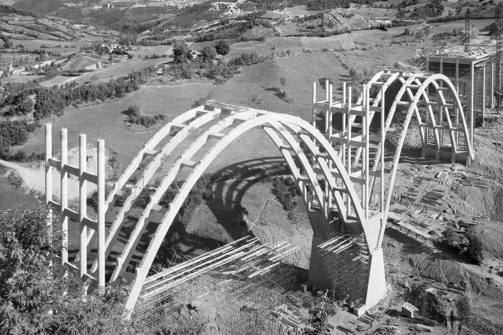
- Professor Tullia Iori, The University of Rome Tor Vergata: ‘Engineering the Italian Landscape: the Autostrada del Sole as Territorial Construct for a New Post-War National Identity’
The list of conference sessions taking place are:
- Mapping, Counter-Mapping, Drawing Lines
- Highways, Vedutismo, Calculations
- Rivers, Water, Flows and Blockages
- Energy, Infrastructure, Connections
- Landscapes, Seen and (de)Constructed
- Sublime Networks: Religious and Scientific
- Labour, Materials, Earth
- Territory, Cultural Identity, Power
- Architectural Localisation / Globalisation
- Geography as Architecture